
In our last post on Besh-Ba-Gowah, we included a link to
more photos on our web album. Being out of practice, I forgot to open that
album to our faithful readers. For those who wanted to see more of
Besh-Ba-Gowah, here’s that link again.Besh-Ba-Gowah
On our way back to Roper Lake from Besh-Ba-Gowah, we decided
to take the scenic route through the San Carlos Apache Reservation, down to
Coolidge Dam and the San Carlos Reservoir on the Gila River. We weren’t at all
disappointed by the drive and the adventure, but we were saddened by the lake.
This picture from the Internet shows what the lake can look like.
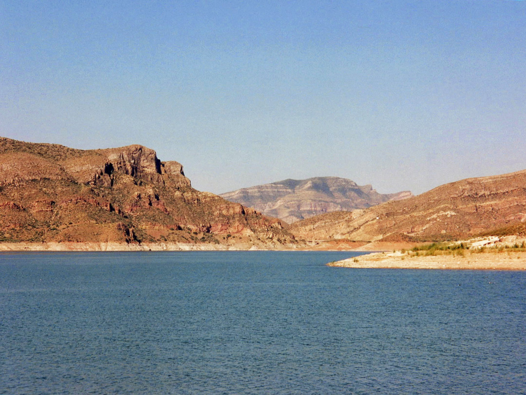
This one we took this year:

And this photo from the Internet shows what the lake could look
like from the dam.
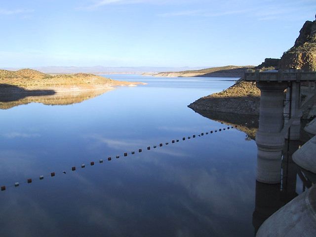
Here is the dam today.

But low water doesn’t deter the hardy souls from their lake
access!

These fellows were just above the dam.

Here's a bit of humor for you: The Coolidge Dam was dedicated in 1930 by President Coolidge. Will Rogers was there, and the San Carlos Lake had not yet begun to fill. Rogers told Coolidge if it was his Dam he'd mow it.
The trip around the lake was quiet, on an almost paved two-lane road.

The scenery was what I'd call desert pleasant. A short distance beyond the dam we saw a sign that read "Bridge Detour - 32 miles." That didn't much bother us. Later we saw a sign warning of the detour in 10 miles. Well, so what? What does a bridge detour consist of? The further we drove, the more we wondered -- will we have to ford a stream? Unlikely, as there's no water anywhere near. Will we have to go miles around?
Then came this sign:

Followed by this:

And that's all it was, we dropped down onto a newly built roadway just to the left of the bridge, then came back up to the road on the other side.
Kind of boring, if we had been looking for excitement. But we like our adventures kind of quiet during this time of ... Our Life on Wheels.
We like to stop at Santa Rosa SP in New Mexico and the Coolidge Lake reminded us of it. The first time we stopped, the lake was up and beautiful. The next time it was down about 25 ft and had sandbars all over the place with the old river clearly visible. Each time we stop there it is different.
ReplyDeleteGerry and I also like to take the road less traveled to see where it goes. We did this a lot when we had our Jeep, but not as much with the Saturn. We need to get a 4 wheel drive vehicle again and see what is out there.
Have fun.
Thanks for fixing the link. I knew you would find out it wasn't working the way you had hoped.
ReplyDeleteOh gracious. That poor lake. That is exactly what San Angelo looks like. What a difference.
Glad the road warnings were a big deal over nothing!
You show the contrast between the lake then and now, and it is really striking.
ReplyDeleteLooks like a really pretty drive...I love the West!..Thanks for letting me sit by the window!
ReplyDeleteWhat a beautiful area. Thanks for taking us along.
ReplyDeleteThe contrast in water levels is quite striking. It reminds me of what Lake Mead looks like compared to just 30 years ago. Great pics!
ReplyDeleteWe need more people like Will Rogers:)
ReplyDeletelook at these guys article source original site Related Site visit this website https://www.dolabuy.co
ReplyDeletex3i97t7k93 m0z72q1y27 b8m17l9d22 j8d58a3f58 u4x89j3v28 l5t27v9a56
ReplyDelete